Into the Wilderness: Exploring the Minnesota Gunflint Trail

Seagull lake

Wildflowers burst along the side of the road and clear lakes sparkled in the warm sun. The scent of the pines covering the gently rolling hills filled the air. And just when I thought life couldn’t possibly be more spectacular in the far northern wilderness of Minnesota along the Gunflint Trail, I was caught in a sudden hailstorm—both humbled and proved completely right. Life is spectacular here.

Although I grew up in the Twin Cities, I’d never ventured farther than Two Harbors when I was younger. Thankfully, two of my siblings have spent decades exploring Minnesota and know where the treasures are tucked away—which is how I came to Grand Marais.

A town of 1,300 people just 40 south of the border with Canada, Grand Marais is many things: Coolest small town in America, French butter scones at The Pie Place, a haven for angry seagulls, jumping off point for gorgeous waterfalls and hikes, and a gateway to the endless Boundary Waters.

grand marais bear pentraveler
I mean, yea. You make a cozy with ears for your wooden bear statue, and you deserve the “coolest small town” ranking.

Grand Marais is also the start of the Gunflint Trail, a very old route for the Ojibwa, the original people of northern Minnesota, and from the 1700s, a trading/traveling route for the early Europeans on the continent. Today, the Gunflint Trail is a route into the wilderness—which you know because you pass a sign with an old-timey voyageur carrying a canoe and a bear in a boat as you turn onto County Road 12 from downtown Grand Marais. And then another trail sign for good measure on a water tank with a moose.

The Gunflint has enough experiences to keep you enthralled for weeks, and enough draw to keep me longing for it even now, weeks back home. If I had to choose (so hard to choose!), here are my Top Five on the Gunflint:

1. Canoe and portage the Boundary Waters Canoe Area.

A 1,090,000-acre wilderness of lakes separated by slivers of forest, hills and glacier-carved rocks, the Boundary Waters stretches from Lake Superior 150 miles west to Voyageurs National Park. With canoes rented from Stone Harbor Outfitters in Grand Marais and my brother’s 10-year-old Princess Pug who had never spent a day hiking in her life, we were totally prepared and excited to explore a small piece of the wilderness.

pug in canoe in boundary waters
This oh-so-dainty Pug can be a bit of a princess. “I’ve never seen a pug in the Boundary Waters before,” one canoer said to us on one of the lakes. Unspoken, but clear from his tone: “I’m not really sure there should be a pug in the Boundary Waters.”

Our route was simple on paper: Clearwater Lake-portage-Caribou Lake-portage-Little Caribou Lake-portage-Pine Lake-Johnson Waterfalls-return. (I swear, on a map, it looks both short and easy.)

Fifteen seconds into the first portage, we realized this was not going to be so easy. First, although the canoes only weighed 40 pounds, we didn’t have shoulder pads for carrying them (major mistake!), so the wood bit into muscles. Second, the portage path was a mud slush over our ankles for nearly 1 mile on the first portage. Third, Princess Pug decided trotting through mud was something she definitely did not want to do.

But being three out of four hardy Midwestern stock, and one very in-shape East Coaster—well, and one city-only-ever-until-now Pug—we sucked it up and took turns portaging the canoes and the pug, trudging through the mud. All of which was immediately forgotten on heavenly Caribou Lake, with its glassy water and only the sounds of birds and the breeze for company.

Caribou Lake MN
More proof that Minnesota in the summer can’t be beat.

Seven hours and fourteen miles later (never believing deceptively easy maps again!), we treated ourselves to 12-inch malts at quirky Trail Center restaurant while the now thoroughly muddy Adventure Pug slept in the car.

2. Discover movie-perfect lodges and quirky restaurants.

Tucked away along the Gunflint Trail are very Northern Minnesota quirky and delicious restaurants catering to locals as well as explorers. If you like beer-battered walleye and wild rice, you will be in heaven. And if you don’t like those two Minnesota staples, please just go on to Wisconsin.

In addition to perfect malts, Trail Center Restaurant has to-die-for bread pudding French toast with pumpkin-spiced maple syrup. If I ever had to eat only one food ever, this would be it. I might end up weighing something like a baby elephant, but I would be happy. And baby elephants are adorable anyway. Trail Center also has 14-inch round, 2-inch thick flapjacks, for which they offer: Eat 3 and they’re free!

pentraveler Trail Center restaurant
The pancakes are about the size of this wheel that hangs from the ceiling at quirky and delicious Trail Center Restaurant on the Gunflint Trail.

Further down the road, the Gunflint Lodge looks like it’s from the setting of a romantic comedy—beautiful wood lodge right on a stunning lake. This one just happens to look across to Canada. (Plot line: Minnesota fisherwoman bumps into Canadian fleeing via the lake. Big reveal: it’s Justin Trudeau! You’re welcome, Hollywood!) The lightly beer-battered walleye with mango chutney and wild rice are as dreamy as the scenery.

wildflowers on the Gunflint Trail
Gunflint Trail so pretty.

3. Look for wildlife during a drive along the Gunflint Trail.

Lupine and other wildflowers (invasive but beautiful) line the roadside, and lakes peak through the pines. In the winter, moose are often sighted licking salt from the road at night.

As my brother the Minnesota birder told us how he’s never seen a lynx in the wild, we crested a slight hill on the Gunflint Trail and in front of us on the road lay—a lynx, clearly injured. At up to 40 pounds and three feet long, these brown and white wild cats are a federally threatened species and roam just a few remote parts of Minnesota. Which doesn’t stop many people from thinking they see them frequently in their backyard, calling the DNR to report a lynx when really it’s just Puddles the Neighbor’s Cat.

We watched as this massive cat staggered to its feet, a paw bent fully backward, and all winced for the animal. Thankfully, it hobbled off the road to avoid further injury, and my brother called the DNR to assist as soon as we got back to service.

lynx in northern MN
Even injured, this powerful Lynx we saw along the Gunflint Trail looked like the powerhouse of a hunter that it is. Hard to imagine confusing house cats for this, but well.

4: Revel in Mother Nature’s summer randomness.

Just a few miles before the Gunflint Trail ends at Gull Lake, my friend and I rented a canoe for a leisurely afternoon paddle on Seagull Lake around on its many islands, sure it would be another gorgeous day like earlier in the week with my brother.

Except as we paddled out, we struggled to maintain forward movement into waves from 10-15 mph winds. And then dark clouds appeared on the horizon. And then we were a little lost in the many islands.

Just as lightening appeared in the much-closer and getting-darker clouds, we docked on a small island and identified the best rock and pine to huddle under. Within minutes, pea-sized hail pelted the ground as thunder shook my bones. The downpour soaked through our pine covering as we watched the islands disappear behind a sheet of rain.

With what looked like a short break in the clouds, we speed-paddled back to the dock, only to get soaked by another wall of rain.

But then, just as quickly, the clouds moved on, and we were back to sunshine and glassy water. I couldn’t help but laugh at the changing weather. Mother Nature in the summer in Minnesota never fails to surprise.

Seagull lake
In about 1.5 hours, we experienced high winds, a hail storm, severe downpour, and glassy water on Seagull Lake near the end of the Gunflint Trail.

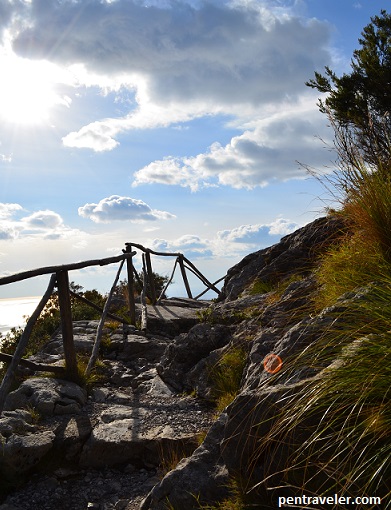
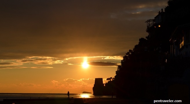
5: Watch the sunset at Honeymoon Bluff.

From Clearwater Road, the pull-off for a short hike up to Honeymoon Bluff is a perfect end to a day on the Gunflint. From a rock outcropping high above Hungary Jack Lake, the sun sets over the pines and the world glows a soft gold to pastel pinks and blues.

honeymoon bluff MN
As the sun set over Hungry Jack Lake, I felt so full.

I long to be back there now, exploring hidden treasures in the sweet air and ever-changing skies. After two amazing Minnesota summer trips in a row, I’m already dreaming of where to explore next in my long-ago home state.

Paradise is Kauai: Top Five Dreamy Experiences on the Garden Isle

Lush tropical forests, sweet clean air, razor-thin ridges that plunge to the sparkling ocean, and gold-pink sunsets—Kauai is a dream from which you don’t want to awaken.

Recently my friend and I spent two weeks in Kauai chasing sunsets, exploring verdant valleys, and laying on as many beaches as possible. The northern most island of the Hawaiian chain, Kauai has 113 miles of shoreline, of which 50 are beaches, so plenty to explore.

Yes, it was a hard two weeks, but I did it for you, Dear Readers.

Okay, I did it for me, too (mostly for me). The only negative: I returned with little pinch-mark bruises on my arms, since about 10 times a day I had to make sure I was awake and this was all real.

Kauai Poipu sunset
This sunset was real at Po’ipu Beach on the south shore of beautiful Kauai. Everything in this blog really happened, as dreamy as it sounds.


If for some tragic reason you can only spend three days in Kauai, here is my must-do Kauai dreams list. The most beautiful, least populated sights required some effort, but were well worth it.

Top Five Dreamy Things to Do in Kauai

Number 1: Take a boat ride along the Na Pali Coast. Yes, you have to get up early (6:45 a.m. arrival to Hanalei Bay). Yes, it may be raining as you wade in the ocean to board your boat. Don’t let these details stop you.

Stretching 15 miles along the northwest shore of Kauai, the Na Pali coast is wild and so severe in formation that only a one-to-three-foot wide hiking trail hugs its cliffside. Otherwise, you can see it by helicopter or boat.

By boat, we sped out of the bay (quite nicely drenched) and as promised the rain dissipated; a massive rainbow stretched from the cliffs to the ocean. The boat hugged the coastline for most of the four-hour tour, and we saw waterfalls 1,800 feet tall plunging through green valleys and spilling out at the ocean, razor-thin cliffs making a cathedral of nature, and battered sea caves opening to the sun. We snorkeled in 30-feet deep crystal clear water, and three pods of dolphins jumped along in the white wake of our boat.

Version 2
When you are staring at one of the most spectacular coastlines in the world, and a rainbow appears, and then DOLPHINS start jumping in front of you—you’ve kind of got to be like: Ok, Nature, dial it back a bit. I got it.

Number 2: Snorkel at Po’ipu Beach. Most of my friends are well acquainted with my (totally rational) fear of sharks in any body of water, let alone the ocean. So I did not commit to snorkeling before we arrived in Kauai. I had, however, committed quite bravely to wading out to mid-shin.

When we arrived on the south shore of Kauai at Po’ipu Beach to read and lay about, I noted the presence of maybe 15 snorkelers swimming inside a reef, which broke the large ocean waves from shore. Through narrowed eyes peering over the top of my kindle, I observed the snorkelers carefully for signs of distress, large pools of blood, or missing limbs as they exited the water.

After an hour, there still seemed to be about 15 of them. No shark losses.

My friend returned from the snorkel rental shop with two sets of masks and fins, so I made the (insanely brave) decision to give it a go. Wading out, I clung to his arm and insisted he swim on the side with the deeper (more sharks) water, because I’m just that good of a person.

In 30 minutes of snorkeling, I hyperventilated only three times, freaked out eight times, and saw at least ten types of incredible fish. Which I took as a rousing success, and even went back twice.

poipu beach
Po’ipu Beach, which has spectacular snorkeling and watching for people who are potentially about to get bitten by sharks. 

Number 3: Watch the sunset and stars at Polihale Beach. As you drive west in Kauai—which you certainly will do if you want to avoid the rain showers that briefly pass through the north and east sides of the island—you will eventually come to the end of the road, where a sign points to Polihale. Make a left, and for six miles you bounce along a dirt, deeply cratered road.

As in, we traveled six miles in 40 minutes. (During which time, we went through varying stages of Jeep and massive truck envy as they zoomed past our compact rental.)

But at the end of that road was Polihale Beach, an unbroken wide stretch of wilderness that fires the heart. We walked to the northern end of the beach where the sand stops and the NaPali coastline begins, marveling at the sheer cliffs. Strong wind whipped the sand against our skin even as the sun kept us warm, so we ducked behind one of the sand dunes back from the water and napped.

By sunset, the wind calmed, and we watched the sun sink below the ocean. As the light faded, we watched the stars pop into the sky. No towns anywhere near to create ambient light, we returned in pitch darkness, the stars shining as neon points in a blanket of black. Only the croaks of frogs and the swish of the breeze in tall grass accompanied us out.

Polihale Beach
We had Polihale Beach almost to ourselves. Well, to ourselves and a few nudists taking selfies. But mostly to ourselves.

Number 4: Hike to a 410-foot waterfall. Kauai has so many waterfalls, two weeks isn’t enough to come close to seeing them all. Of the ones I did see, Hanakapi’ai Falls was my favorite, partially because of the strenuous route to get there, which requires hiking the first two miles of the Kalalau Trail, often ranked as one of the world’s best hikes. At just .5 miles in (and several hundred feet up), we encountered stunning views of the Na Pali coast. At 2 miles in, we arrived at Hanakapi’ai Beach, where you do not swim—as attested to by makeshift memorials for hikers who have done so. 

From the beach, we hiked into the heart of the Hanakapi’ai Valley through lush and changing vegetation, including palm trees, blankets of hot pink flowers, and soaring bamboo. Following days of heavy rain on the north shore, we crossed four major (sign-warned) streams, 14 minor streams, and slogged through miles of muddy trail—twice. Some distance up the trail, we learned from a returning hiker that a group of hikers had been caught on the opposite bank of a stream crossing the day before during a flash flood, and had spent the night there.

Now, granted, Kauai has no predators in the wild (but a heck of a lot of wild chickens) and no snakes. The average temperature in April ranges from 69F at night to 79F in the day. There are worse places to get caught overnight.

The Hanakapi’ai waterfall was a cooling reward, its spray fiercely coating everything nearby given its four-lane width. I ate lunch and admired both Hanakapi’ai and the six other falls spilling down the cliffs.

Hanakapiai Falls
Oh, just another gorgeous thing in Kauai. Hanakapi’ai Falls, a 4+ mile hike along the Na Pali coast and then into a very muddy and gorgeous valley.

Number 5: Explore Waimea Canyon. There is an easy way and less-easy-but-more-gorgeous way to do this. Easy = drive and stop at the five viewpoints that put you on the edges of the “Grand Canyon of Hawaii.” Less-easy but so much more rewarding = hike some of the many miles of trails in the park.

waimea canyon 2
You make it to the overlook, where you are hanging on the top edge of this canyon, and one thought undoubtedly rises stronger than any other: Meh.

From the final viewpoint of the canyon’s drive, the Alaka’i Swamp trail took us 8 miles and 5.5 hours to hike. Every curve was breathtaking, from walking along a brick red ridge on the top of the trees to a meandering boardwalk through a swamp at 3500 feet, and then, finally, hiking right into and through a cloud.

And somehow in all the beauty of the rest of that hike, I keep forgetting to mention—it began on a ridge overlooking a lush valley that plunges to the ocean (which happens to be Kalalau Valley, which you hopefully saw by boat earlier!).

Akali swamp trail Kauai
It was really hard picking photos for this blog post. Kauai is just too freaking gorgeous. These are the clouds rolling in over the top of the island, which you float along during your hike on the Alaka’i Swamp trail.

Incredibly Close Runners Up: More Amazing Things to Do in Kauai

You would probably regret missing any of these, too, so definitely take more than three days for Kauai if you are an outdoors-lover. I also can’t recommend enough:

  • Chilling to live music, Mai Tai in hand, at Duke’s Bafefoot Restaurant on the beach in Lihue.
  • Hanging (from afar) with sea turtles and monk seals (both protected, so don’t get too close) that come up on the shore in Po’ipu.
  • Drinking the best-ever fresh juice at Kauai Juice Co.
  • Savoring coconut and pineapple pancakes at Olympic Café in Kapa’a.
  • Finding serenity with yoga on the beach at sunrise.
  • Discovering your favorite beach.

Bottom line: Hard to go wrong in Kauai. The only wrong decision, it turns out, might be to return to the mainland.

Version 2
One more dreamy shot of the Na Pali coast, this one from the Kalalau Trail .5 mile viewpoint.

Walking the Path of the Gods in Italy

In Italy, the evidence of belief is everywhere in gorgeous, glorious form. The columns of the Temple of Vesta stand sentinel over the remains of Rome’s ancient forum, a radiant dove watches from high above St. Peter’s tomb in the Basilica, and carved into smooth marble, Cupid and Psyche embrace for eternity in Florence’s Uffizi museum. But of all the beautiful buildings and prized masterpieces in Italy, I found conviction most clearly in the landscape—Amalfi Coast’s Path of the Gods.

I’d originally envisioned a January hike through the Amalfi Peninsula as another multi-day Patagonia-like affair, including one day on the famous Path of the Gods, or Sentiero degli Dei. It seemed entirely possible from the blogs and one book on the topic, and I’d done at least three whole hours of planning. My friend and I would hike from the town of Amalfi to the town of Sant’Agata over three days, stopping for pasta and wine and a comfortable bed.

Hard to go wrong.

Of course, when we arrived to Salerno—the point for which we would take a SITA bus to Amalfi—it was snowing and windy, and everything absolutely did go wrong.

Undeterred, and with a slightly-above-freezing temperature in Praiano the next morning, my friend and I asked our hotel owner for directions to the Path of the Gods. He took us to the window and traced the path we would climb up the steep mountainside. It wouldn’t be the full Path of the Gods, but it would be the most beautiful part.

“Up to the convent, then up again, over to that town, then down to Positano,” he explained. “Two hours, no problem.”

path of the gods pentraveler
From Praiano, the Path of the Gods is straight up to a convent, then west to Nocelle, then down to Positano.

“Easy peasy,” I said to my friend. “I bet we could make it all the way to the end of the peninsula if we wanted to.”

amalfi peninsula pentraveler
Just to be clear on the extent of my delusion–you can barely see the end of the peninsula in this photo. I thought I could hike this whole thing in one day. On the plus side, no one can say I’m lacking self-confidence.

The hotel owner pointed us to the stairs across the street from our hotel, conveniently marked with a “Path of the Gods” sign. Up we climbed through the town’s narrow stairs, flanked by white houses and framed with bright pink flowers and lemon trees. Painted Roman myths mixed with Christian paintings and sculptured gods dotted the climb along the stair’s wall and then the forest as we gained elevation.

path of the gods 1 pentraveler
I think this is Medusa.Or the sun with curly rays.

Thankfully, the wind had quieted today, none of the fierce gusts of the previous days in Italy this trip.  The sun rose and warmed our skin, although a broken pipe pouring water into a spontaneous ice sculpture reminded us that it was still quite cold.

At about stair number 1,000+, we reached the convent of San Domenico and the church of Santa Maria a Castro, a sweet rest stop. Two men and a dog arrived shortly after us—one, the caretaker of the convent, opened the small church and asked if we wanted a snack.

Never one to turn down an espresso in Italy, I chatted with the man, practicing my Italian.

He said for a few days in the summer everyone from the village comes up to the small church for a special mass, the whole area lit with candles. Inside, the church was cool and dark, its frescoed walls looking untouched since the 1400s when it was built.

san domenico pentraveler
Easy to imagine this beautiful church from the 1400s filled with candlelight.

Freshly caffeinated, we continued up past the church, where the Path of the Gods was immediately less clear. Exposed small rocks led up with a sharp vertical drop to the side. We scrambled up, wondering aloud if we were still on the path.

But then—a sign. (An actual one, no doves or anything like that.) To the right, a hike to the summit, and to the left, continuing the path to Positano. We veered left, walking the two-foot ledge fit snuggly into the cliff. I say “snuggly”, because I am happy being literally dangled from a rope two stories high, but if you have a fear of heights, this is probably not the path for you.

path of the gods 3 pentraveler
It helps to think of these types of paths in comforting terms because otherwise you might just be terrified you are 400m/1300ft+ above sea level with a sheer drop to your left.

Time faded as we followed the mountains’ curves into hollows and out along its ridges. We passed a ruined house and belled goats roaming above us on the mountainside. The path widened briefly, where a couple sat snacking on the most amazing location for a picnic bench I’ve ever seen. White and orange markers reassured from time to time that we were, in fact, going the right way.

mary statue path of the gods pentraveler
Every second of the Path of the Gods is breathtaking. Sometimes because you think you are going to fall off the cliff edge, but mostly because of the view.

The exposed cliff toyed with perspective, feeling never quite closer to our final destination, and I finally admitted there was no way we were making it to the edge of the peninsula today.

Eventually, we started a descent that curved back along a hollow into a wooded area, then out again with guard rails appearing as we approached the town of Nocelle.

guardrail path of the gods pentraveler
Don’t be fooled, guard rails are very rare on the Path of the Gods.

In Nocelle, the first sight that greeted us: The Kiosk of the Path of the Gods. Closed. “Get your prosecco here!” the sign said anyway.

I glowered at the sign. I wanted that a bubbly drink very much after the last four hours. Why had our owner said only two?! Until that moment, I’d been quite happy with our nearly solo January walk—we’d passed only seven other hikers the whole time. But faced with a closed refreshing beverage shop, I had my moment of doubt.

Just then, two cats appeared, purring like little motor boats, so I took the solace they offered, and we started the descent through lovely Nocelle. 1,700 stairs of descent, to be exact.

nocelle stairs pentraveler
Purring cats in Nocelle tried their hardest to make up for the closed beverage shops.

By the time we reached the road, I was ready to fall to my knees—not just in gratitude for being done with the stairs, but also because 1,700 stairs is A LOT.

We crawled/walked the last stretch to Positano and collapsed into the first restaurant we found open along the beach. With a glass of prosecco and gnocchi on the table, the stairs were forgiven and I found all that was left in my heart was the lightness, once again, of a beautiful experience.

positano sunset pentraveler
The sunset over the Mediterranean Sea in January from the nearly empty beach in Positano is something to behold, and hold onto, long after it has sunk below the waters.